
Mahwah Neighbors Block Sources
Public records about a Mahwah block are relationship records. One source identifies a parcel and another records a deed party, planning applicant, election district, or organization contact. The source that answers a boundary question may not answer an owner question. Start with the exact address and municipality, then keep the property's situs address, owner mailing address, recorded party, and occupant as separate fields. That approach avoids turning an orientation map or dated planning notice into a claim about who lives beside a particular address.
| Source | What It Shows About a Block | Access |
|---|---|---|
| New Jersey municipality lookup | Whether a full address resolves to the relevant municipality | Official online address, city, state, and optional ZIP lookup |
| Bergen County Parcel Viewer | Parcel geometry and visible map orientation around the address | County viewer; verify layers and dates in the live map |
| Mahwah assessor and planning records | Block and lot context, or certified affected owners for a specific application | Assessor, clerk, OPRA, or application-specific request route |
| Mahwah election district table | Street number range, parity, district, and polling-place geography | Current local crosswalk, not a name roster |
| Township resource directory | Published civic and organization contacts | Category, name, and alphabet browsing; no membership list located |
The county GIS viewer is for orientation. It does not replace a survey, a current assessor record, or a recorded instrument. Mahwah's assessor page does not offer a public owner-name search and directs property-information requests through the municipal clerk and OPRA process. A mailing address can belong to an owner or other recipient, while the situs address identifies the parcel itself. Neither one confirms an occupant.
Map a Mahwah Neighbor Block
Use a short chain from an address to its surrounding parcels. This is an orientation method, not a census of Mahwah neighbors. Resolve the municipality before using the map, because postal wording and municipal boundaries can differ. Then use the map and records to identify which question each result can answer.
- Enter the complete address into the municipality lookup and preserve the returned municipality with the search date.
- Open the same address in the Bergen County Parcel Viewer to orient the parcel and visible surrounding parcel shapes.
- Record the block and lot only after confirming it with a municipal or county source. Treat the GIS display as geographic context.
- For a recorded owner or party question, use the Bergen land-record index and keep the instrument date and party role.
- For a planning application, ask whether a certified 200-foot owner list exists for that specific application and date.
This produces a useful flow: exact address to municipality, parcel orientation, block and lot, recorded role, then a dated planning or election record when applicable. For a full named-street records chain rather than the immediate block, use the Mahwah by-street directory.
Confirm Mahwah Before Neighbor Research
Do not use a ZIP alone to define a Mahwah block. The official municipality lookup accepts a street address, city, state, and optional ZIP, and is the appropriate way to resolve a complete address when postal-city language is uncertain. Bergen GIS then supplies parcel orientation. The research found no stable public layer list or historical coverage date in the viewer shell, so check the live layer information before relying on a boundary or feature.
New Jersey's municipality lookup is the first official step when an address needs to be tied to Mahwah rather than assumed from a postal label.
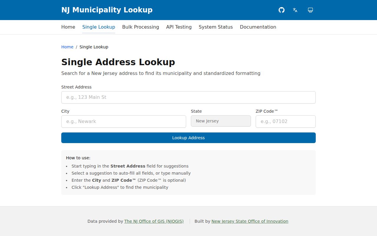
The returned municipality is a geographic check. It still does not identify a household, parcel owner, or organization member.
Mahwah Neighbors and the 200-Foot List
Insider tip: Mahwah's certified 200-foot owner list is a planning-application record, not an on-demand neighborhood list. The township planning application directs the applicant to obtain the list from the Tax Assessor. The listed township fee is $10, and the application says the assessor forwards it within seven days. Its value is that it preserves affected property owners for a defined application and date.
Ask for the application number or date before relying on the list. It does not establish a historical run, and it does not identify every person associated with a block. The record names owners the assessor treated as within the stated distance for that proceeding. Preserve the planning purpose and date with the list, then use a deed or assessor channel when a parcel question needs confirmation.
Note: A certified 200-foot list is strongest as a dated planning record, not as evidence of present occupancy or community membership.
Mahwah Neighbor Districts Need Parity
Insider tip: Search the Mahwah election district table by exact street number and parity. The township assigns fourteen districts, but long streets and even or odd ranges can split the assignment. Airmount Road, for example, places even addresses in District 1 and odd addresses in District 2. Armour Road also has different number ranges assigned to Districts 1 and 2. A street name by itself is not enough to select a district or polling site.
The table is a geographic crosswalk. It can help place an address in the local election framework, but it does not name voters. Keep older street labels visible when researching older records. The township page lists Adams Court as formerly Jefferson Street, Fike Road as now Settlers Road, and Franklin Place as now Sustack Place. No official rename year was located, so do not assign one.
Mahwah Neighbor Voter Access Limits
The online New Jersey voter-status check responds to an entered registration record. It is not a searchable block roster. A full voter list is a statutory request to the county registration custodian, not an extension of the status page. New Jersey rules include redactions for signatures and personal identifiers, special treatment for protected addresses, and a statutory electronic-list cost cap. Direct a request to the correct county custodian instead of the assessor or GIS office.
A status result also needs context. It can reflect a prior address, an inactive record, or an address-protection program. The Superintendent of Elections and Commissioner of Registration administer registration functions in Bergen County, while the Board of Elections has separate polling-site and district roles. Use the election district table for address geography and the voter channel only for the narrow question it can answer.
Mahwah Neighbor Public Contacts
Mahwah's township resource directory is a public contact tool, not a neighborhood roster. The inspected directory offered category, name, and alphabet browsing and showed about 30 listings. It includes Community Associations of Mahwah, CERT, Rotary, scouting, 4-H, the Elks Lodge, Mahwah Emergency Medical Services, the Mahwah Democratic Club, the Mahwah Education Association, religious organizations, utilities, transportation, and school contacts. Contact an organization through the published channel to ask about public events or historical material.
Community Associations of Mahwah
Public directory contact: Ellen Stein, P.O. Box 857, Mahwah, NJ; 201-327-4060. Confirm the listing remains current before using it.
Other public directory categories
CERT, civic groups, scouts, emergency services, religious organizations, utilities, transportation, and school contacts appear as categories or public listings.
No official public roster of association members, block captains, or neighborhood residents was located. A name near an organization or a meeting place is not evidence of membership. Cite only information the organization has made public.
Mahwah Neighbor Property Alert Myth
Myth: a property-record alert identifies the people around a Mahwah address or prevents every fraudulent filing. Bergen County Property Alert is a free prospective alert service. After verification, official guidance says alerts usually arrive within five to seven business days. It can alert an enrolled party to matching recorded-property activity, but it is not a historical neighbor directory and it does not prevent fraud.
Bergen County Property Alert provides the official enrollment view for a Mahwah property-record alert.
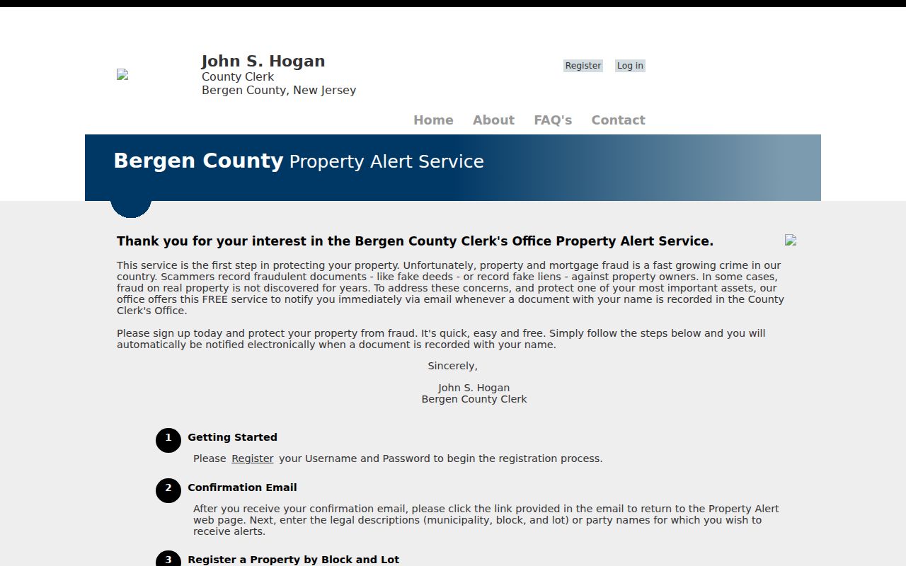
Use an alert as a prompt to review a recorded instrument with the county, not as a substitute for the instrument, a title review, or a block record.
Mahwah Neighbors Source Comparison
Official records identify the keeper, purpose, and date of a particular record. Commercial neighbor-search categories can combine public and private material without showing the original context. For a Mahwah block, the official route is more useful because it preserves the difference among a parcel, a recorded party, a planning-list owner, a voter status, and a published civic contact.
| Official block record | Commercial data category |
|---|---|
| Identifies a custodian, date, and record purpose | May combine material with unclear source dates |
| Allows comparison with an underlying deed, planning file, or election table | May not provide original document context |
| Supports a correction request to the actual custodian | Correction and opt-out practices can differ by provider |
Mahwah Neighbors Privacy Limits
New Jersey's Address Confidentiality Program gives qualifying participants a legal substitute address. Do not attempt to reverse-engineer a residential location from a public record, map, or related listing. OPRA redactions protect personal identifiers and protected addresses. Court and vital-record systems also exclude or restrict some material. No public source reviewed provides a complete Mahwah list of occupants, association members, or household connections.
Use a parcel, planning, election, or civic record only for its stated purpose. Record the original URL, the date checked, the record number where available, and the custodian. When a detail is wrong, contact the office or organization that created it rather than republishing a disputed claim.
Lawful use. Use Mahwah neighbor records for personal, lawful research and civic context. Never use a result to stalk, harass, intimidate, or harm another person.